Laser Scanning Systems - study material
3. Measurement Using Terrestrial Laser Scanners
3.1. Preparation for measurement
During the reconnaissance, the surface and the shape of the scanned object and its structural elements are detected. Based on the information obtained about the object, the configuration of scanner stations and reference points are planned with respect to the type and characteristics of the scanner used such as range, the field of view, and accuracy.
If it is not possible to scan the measured object from a single station, it is often necessary to choose reference points in the scanning site. The reference points are then used to merge several different point clouds into one common coordinate system. They can be signalized naturally directly on the measured object (e.g., sharp edge, spherical shapes, or its parts), or they can be signalized artificially using targets. The majority of scanning systems use a particular type of target for reference points which are automatically recognized by the scanning system. They may be plane or spherical, alternatively hemispherical targets. After scanning of spherical targets, a sphere is fitted to the points lying on the surface of the target and its estimated center is used as a reference point. Other types of targets are plane targets with a retroreflective surface, which are recognized by the scanning system based on the high intensity of the reflected measuring signal or targets with high contrast between parts of the target (so-called checkerboard targets). In Fig. 6 there are some of the target types used for signalization of reference points – target Leica HDS (on the left), checkerboard target (in the middle), and spherical target (on the right).
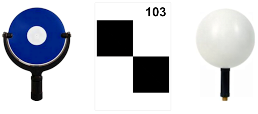
Figure 6 Examples of reference points
In many cases, it is necessary to create the 3D model of the measured objects in a given coordinate system (local coordinate system of the measured object or national coordinate system). The coordinates of selected reference points have to be determined in the given coordinate system by other conventional surveying methods. The results of scanning are transformed based on these points into the defined coordinate system using spatial transformation.
An integral part of the preparation works is planning and implementation of occupational safety and health protection as well as the protection of instruments and equipment during the measurement. This is important mainly in industrial factories because the measurements are often realized during the full operation of objects. When choosing an instrument, it is necessary to consider the environmental conditions in which the measurements are realized, they can extremely differ from the conditions in other environments, e.g., urban areas. The instrument has to be often protected against extreme dust and humidity. Measurements are often realized in a chemically aggressive environment what significantly influences the form of stabilization of reference points (using a normal metal anchorage is not possible), or the measurements are realized in explosive conditions (instruments need certificate for explosive conditions).